
Key Insights
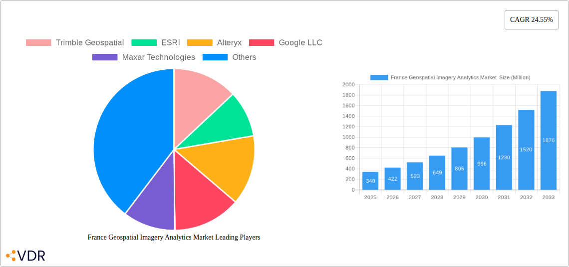
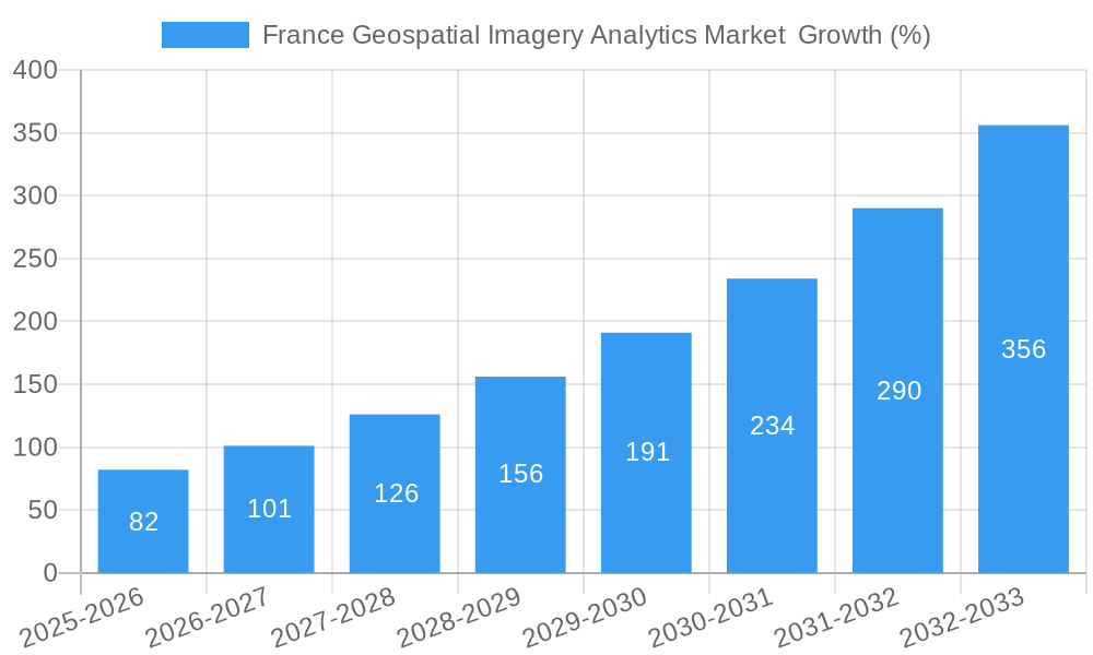
The French geospatial imagery analytics market, valued at €340 million in 2025, is projected to experience robust growth, driven by increasing government investments in infrastructure development, precision agriculture initiatives, and the burgeoning need for enhanced security and environmental monitoring. The market's Compound Annual Growth Rate (CAGR) of 24.55% from 2025 to 2033 indicates significant expansion potential. Key drivers include the rising adoption of cloud-based solutions offering scalability and cost-effectiveness, along with advancements in AI and machine learning algorithms enhancing the accuracy and speed of data analysis. The market is segmented by vertical (insurance, agriculture, defense & security, environmental monitoring, engineering & construction, government, others), type (imagery analytics, video analytics), deployment mode (on-premise, cloud), and organization size (SMEs, large enterprises). The strong presence of major players like Trimble Geospatial, ESRI, and Google LLC, coupled with a growing ecosystem of specialized service providers, further fuels market expansion. While data privacy concerns and the high initial investment costs associated with advanced analytics solutions may pose some challenges, the overall market outlook remains positive, with consistent growth expected throughout the forecast period.
The dominance of cloud-based deployment is expected to continue, given its advantages in accessibility, scalability, and reduced infrastructure costs. Within the vertical segments, the agriculture sector is poised for significant growth due to the increasing adoption of precision farming techniques. The defense and security sector will also contribute significantly, leveraging geospatial imagery for surveillance, border control, and strategic planning. The government sector's investment in smart city initiatives and infrastructure monitoring will further bolster market growth. Competition among established players and emerging startups is expected to intensify, fostering innovation and driving down prices, ultimately benefiting end-users. The continued refinement of analytical techniques and the integration of various data sources will lead to more comprehensive and actionable insights, widening the application of geospatial imagery analytics across diverse sectors in France.
France Geospatial Imagery Analytics Market: A Comprehensive Report (2019-2033)
This in-depth report provides a comprehensive analysis of the France Geospatial Imagery Analytics Market, offering invaluable insights for industry professionals, investors, and strategic decision-makers. The study covers the period 2019-2033, with a focus on the base year 2025 and a forecast period extending to 2033. The report segments the market by verticals (Insurance, Agriculture, Defense and Security, Environmental Monitoring, Engineering & Construction, Government, Others), type (Imagery Analytics, Video Analytics), deployment mode (On-Premise, Cloud), and organization size (SMEs, Large Enterprises). Key players such as Trimble Geospatial, ESRI, Alteryx, Google LLC, Maxar Technologies, Hexagon AB, Microsoft Corporation, Oracle Corporation, L3 Harris Corporation, and Orbital Insights are analyzed for their market strategies and contributions.
The report's value is quantified in million units. Where specific values are unavailable, we use "xx" to represent predicted or estimated figures.
France Geospatial Imagery Analytics Market Dynamics & Structure
This section analyzes the market's competitive landscape, technological advancements, regulatory environment, and market trends. We examine market concentration, assessing the market share held by key players and exploring potential shifts in market power. Technological innovation is examined, including the impact of advancements in AI, machine learning, and high-resolution imagery. The influence of relevant regulations on data privacy and security are discussed, along with the availability of alternative technologies and their impact on the market. Finally, mergers and acquisitions (M&A) activity within the industry are analyzed, providing insights into strategic collaborations and consolidations.
- Market Concentration: The French geospatial imagery analytics market is moderately concentrated, with xx% market share held by the top 5 players in 2025.
- Technological Innovation: Advancements in AI-powered image recognition and analysis are driving market growth, improving accuracy and efficiency.
- Regulatory Framework: Data privacy regulations (e.g., GDPR) influence data handling and storage practices within the market.
- Competitive Substitutes: Traditional surveying methods and other data sources pose some competition, although the market is growing rapidly.
- End-User Demographics: Large enterprises currently dominate the market, but adoption among SMEs is increasing.
- M&A Trends: A moderate number of M&A deals (xx) were observed during the historical period (2019-2024), indicating a trend towards consolidation.
France Geospatial Imagery Analytics Market Growth Trends & Insights
This section details the market's historical and projected growth trajectory, exploring factors influencing adoption rates and consumer behavior shifts. The analysis leverages market research data, industry reports, and expert interviews to provide a comprehensive understanding of market size evolution and future trends.
The France Geospatial Imagery Analytics market witnessed a CAGR of xx% during the historical period (2019-2024), reaching a market size of xx Million in 2024. Driven by increasing government investments in infrastructure development and the growing adoption of advanced technologies, the market is projected to expand significantly, with a projected CAGR of xx% during the forecast period (2025-2033). Market penetration is expected to increase from xx% in 2025 to xx% in 2033. Technological disruptions such as the increased accessibility of cloud-based solutions are accelerating market growth.
Dominant Regions, Countries, or Segments in France Geospatial Imagery Analytics Market
This section identifies the leading segments and regions within the French geospatial imagery analytics market based on revenue generated. The analysis focuses on factors contributing to their dominance, including market size, growth potential, and economic conditions.
- By Vertical: The Defense and Security sector holds the largest market share (xx%) in 2025, driven by government investments in national security and surveillance. The Agriculture and Environmental Monitoring sectors are also exhibiting strong growth.
- By Type: Imagery Analytics dominates the market (xx%), with Video Analytics showing potential for significant growth due to increasing availability of drone technology and improvements in video processing capabilities.
- By Deployment Mode: Cloud-based solutions are rapidly gaining traction (xx%), driven by cost-effectiveness and scalability compared to on-premise solutions.
- By Organization Size: Large enterprises currently lead the market (xx%), but increasing awareness and accessibility of solutions are driving growth among SMEs.
The Ile-de-France region is the leading market within France, due to its high concentration of government agencies and technology companies.
France Geospatial Imagery Analytics Market Product Landscape
The market offers a range of solutions, from basic image processing software to sophisticated AI-powered platforms. These solutions vary in features, pricing, and deployment methods. The trend is toward integrated solutions providing streamlined workflows and advanced analytics capabilities. Product innovations are focused on improving accuracy, efficiency, and accessibility through cloud-based platforms and AI-driven features. Unique selling propositions often center on specialized algorithms, integration with other software, and comprehensive support services.
Key Drivers, Barriers & Challenges in France Geospatial Imagery Analytics Market
Key Drivers:
- Increasing government investment in infrastructure projects and smart city initiatives.
- Growing demand for accurate and timely geospatial data across various sectors.
- Advancements in AI, machine learning, and sensor technology.
- Rising adoption of cloud-based geospatial analytics solutions.
Key Challenges & Restraints:
- High initial investment costs for sophisticated solutions can hinder market adoption among SMEs.
- Data privacy and security concerns limit the adoption of cloud-based solutions.
- The shortage of skilled professionals and lack of awareness among users present significant barriers. xx% of businesses surveyed cited skills gap as a barrier to adoption.
Emerging Opportunities in France Geospatial Imagery Analytics Market
Emerging opportunities include the expansion into untapped markets like precision agriculture, increased integration with IoT devices, and the development of specialized solutions for niche applications such as autonomous vehicle navigation and disaster response. The growing use of drones and other UAVs for data collection is opening up new possibilities.
Growth Accelerators in the France Geospatial Imagery Analytics Market Industry
Long-term growth will be accelerated by technological breakthroughs such as improved sensor technologies and more powerful AI algorithms. Strategic partnerships between technology providers and data users, and expansion into new vertical markets and geographic locations will also significantly influence market growth.
Key Players Shaping the France Geospatial Imagery Analytics Market Market
- Trimble Geospatial
- ESRI
- Alteryx
- Google LLC
- Maxar Technologies
- Hexagon AB
- Microsoft Corporation
- Oracle Corporation
- L3 Harris Corporation
- Orbital Insights
Notable Milestones in France Geospatial Imagery Analytics Market Sector
- 2020: Introduction of a new high-resolution satellite imagery service by a major provider.
- 2022: Launch of a government initiative to promote the use of geospatial data in infrastructure planning.
- 2023: Several strategic partnerships formed between geospatial analytics companies and government agencies.
- 2024: Successful completion of xx M&A deals within the market.
In-Depth France Geospatial Imagery Analytics Market Market Outlook
The France Geospatial Imagery Analytics market is poised for sustained growth, driven by technological advancements, increasing data accessibility, and rising demand across various sectors. Strategic investments in R&D, expansion into new markets and technological innovations will shape the future landscape. The market presents significant opportunities for both established players and new entrants, particularly within the growing segments of AI-powered analytics and cloud-based solutions.
France Geospatial Imagery Analytics Market Segmentation
-
1. Type
- 1.1. Imagery Analytics
- 1.2. Video Analytics
-
2. Deployment Mode
- 2.1. On Premise
- 2.2. Cloud
-
3. Organization Size
- 3.1. SMEs
- 3.2. Large Enterprises
-
4. Vericals
- 4.1. Insurance
- 4.2. Agriculture
- 4.3. Defense and Security
- 4.4. Environmental Monitoring
- 4.5. Engineeting & Construction
- 4.6. Government
- 4.7. Others
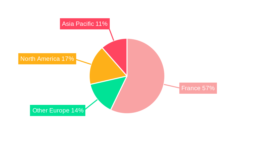
France Geospatial Imagery Analytics Market Segmentation By Geography
- 1. France
France Geospatial Imagery Analytics Market REPORT HIGHLIGHTS
| Aspects | Details |
|---|---|
| Study Period | 2019-2033 |
| Base Year | 2024 |
| Estimated Year | 2025 |
| Forecast Period | 2025-2033 |
| Historical Period | 2019-2024 |
| Growth Rate | CAGR of 24.55% from 2019-2033 |
| Segmentation |
|
Table of Contents
- 1. Introduction
- 1.1. Research Scope
- 1.2. Market Segmentation
- 1.3. Research Methodology
- 1.4. Definitions and Assumptions
- 2. Executive Summary
- 2.1. Introduction
- 3. Market Dynamics
- 3.1. Introduction
- 3.2. Market Drivers
- 3.2.1. Increasing Adoption of Location-based Services; Increasing Demand for Safe and Secure Mining Operations
- 3.3. Market Restrains
- 3.3.1. Legal and Regulatory Hurdles
- 3.4. Market Trends
- 3.4.1. Cloud Segment is Expected to Hold a Significant Share of the Market
- 4. Market Factor Analysis
- 4.1. Porters Five Forces
- 4.2. Supply/Value Chain
- 4.3. PESTEL analysis
- 4.4. Market Entropy
- 4.5. Patent/Trademark Analysis
- 5. France Geospatial Imagery Analytics Market Analysis, Insights and Forecast, 2019-2031
- 5.1. Market Analysis, Insights and Forecast - by Type
- 5.1.1. Imagery Analytics
- 5.1.2. Video Analytics
- 5.2. Market Analysis, Insights and Forecast - by Deployment Mode
- 5.2.1. On Premise
- 5.2.2. Cloud
- 5.3. Market Analysis, Insights and Forecast - by Organization Size
- 5.3.1. SMEs
- 5.3.2. Large Enterprises
- 5.4. Market Analysis, Insights and Forecast - by Vericals
- 5.4.1. Insurance
- 5.4.2. Agriculture
- 5.4.3. Defense and Security
- 5.4.4. Environmental Monitoring
- 5.4.5. Engineeting & Construction
- 5.4.6. Government
- 5.4.7. Others
- 5.5. Market Analysis, Insights and Forecast - by Region
- 5.5.1. France
- 5.1. Market Analysis, Insights and Forecast - by Type
- 6. Competitive Analysis
- 6.1. Market Share Analysis 2024
- 6.2. Company Profiles
- 6.2.1 Trimble Geospatial
- 6.2.1.1. Overview
- 6.2.1.2. Products
- 6.2.1.3. SWOT Analysis
- 6.2.1.4. Recent Developments
- 6.2.1.5. Financials (Based on Availability)
- 6.2.2 ESRI
- 6.2.2.1. Overview
- 6.2.2.2. Products
- 6.2.2.3. SWOT Analysis
- 6.2.2.4. Recent Developments
- 6.2.2.5. Financials (Based on Availability)
- 6.2.3 Alteryx
- 6.2.3.1. Overview
- 6.2.3.2. Products
- 6.2.3.3. SWOT Analysis
- 6.2.3.4. Recent Developments
- 6.2.3.5. Financials (Based on Availability)
- 6.2.4 Google LLC
- 6.2.4.1. Overview
- 6.2.4.2. Products
- 6.2.4.3. SWOT Analysis
- 6.2.4.4. Recent Developments
- 6.2.4.5. Financials (Based on Availability)
- 6.2.5 Maxar Technologies
- 6.2.5.1. Overview
- 6.2.5.2. Products
- 6.2.5.3. SWOT Analysis
- 6.2.5.4. Recent Developments
- 6.2.5.5. Financials (Based on Availability)
- 6.2.6 Hexagon AB
- 6.2.6.1. Overview
- 6.2.6.2. Products
- 6.2.6.3. SWOT Analysis
- 6.2.6.4. Recent Developments
- 6.2.6.5. Financials (Based on Availability)
- 6.2.7 Microsoft Corporation
- 6.2.7.1. Overview
- 6.2.7.2. Products
- 6.2.7.3. SWOT Analysis
- 6.2.7.4. Recent Developments
- 6.2.7.5. Financials (Based on Availability)
- 6.2.8 Oracle Corporation
- 6.2.8.1. Overview
- 6.2.8.2. Products
- 6.2.8.3. SWOT Analysis
- 6.2.8.4. Recent Developments
- 6.2.8.5. Financials (Based on Availability)
- 6.2.9 L3 Harris Corporation
- 6.2.9.1. Overview
- 6.2.9.2. Products
- 6.2.9.3. SWOT Analysis
- 6.2.9.4. Recent Developments
- 6.2.9.5. Financials (Based on Availability)
- 6.2.10 Orbital Insights
- 6.2.10.1. Overview
- 6.2.10.2. Products
- 6.2.10.3. SWOT Analysis
- 6.2.10.4. Recent Developments
- 6.2.10.5. Financials (Based on Availability)
- 6.2.1 Trimble Geospatial
List of Figures
- Figure 1: France Geospatial Imagery Analytics Market Revenue Breakdown (Million, %) by Product 2024 & 2032
- Figure 2: France Geospatial Imagery Analytics Market Share (%) by Company 2024
List of Tables
- Table 1: France Geospatial Imagery Analytics Market Revenue Million Forecast, by Region 2019 & 2032
- Table 2: France Geospatial Imagery Analytics Market Volume K Unit Forecast, by Region 2019 & 2032
- Table 3: France Geospatial Imagery Analytics Market Revenue Million Forecast, by Type 2019 & 2032
- Table 4: France Geospatial Imagery Analytics Market Volume K Unit Forecast, by Type 2019 & 2032
- Table 5: France Geospatial Imagery Analytics Market Revenue Million Forecast, by Deployment Mode 2019 & 2032
- Table 6: France Geospatial Imagery Analytics Market Volume K Unit Forecast, by Deployment Mode 2019 & 2032
- Table 7: France Geospatial Imagery Analytics Market Revenue Million Forecast, by Organization Size 2019 & 2032
- Table 8: France Geospatial Imagery Analytics Market Volume K Unit Forecast, by Organization Size 2019 & 2032
- Table 9: France Geospatial Imagery Analytics Market Revenue Million Forecast, by Vericals 2019 & 2032
- Table 10: France Geospatial Imagery Analytics Market Volume K Unit Forecast, by Vericals 2019 & 2032
- Table 11: France Geospatial Imagery Analytics Market Revenue Million Forecast, by Region 2019 & 2032
- Table 12: France Geospatial Imagery Analytics Market Volume K Unit Forecast, by Region 2019 & 2032
- Table 13: France Geospatial Imagery Analytics Market Revenue Million Forecast, by Country 2019 & 2032
- Table 14: France Geospatial Imagery Analytics Market Volume K Unit Forecast, by Country 2019 & 2032
- Table 15: France Geospatial Imagery Analytics Market Revenue Million Forecast, by Type 2019 & 2032
- Table 16: France Geospatial Imagery Analytics Market Volume K Unit Forecast, by Type 2019 & 2032
- Table 17: France Geospatial Imagery Analytics Market Revenue Million Forecast, by Deployment Mode 2019 & 2032
- Table 18: France Geospatial Imagery Analytics Market Volume K Unit Forecast, by Deployment Mode 2019 & 2032
- Table 19: France Geospatial Imagery Analytics Market Revenue Million Forecast, by Organization Size 2019 & 2032
- Table 20: France Geospatial Imagery Analytics Market Volume K Unit Forecast, by Organization Size 2019 & 2032
- Table 21: France Geospatial Imagery Analytics Market Revenue Million Forecast, by Vericals 2019 & 2032
- Table 22: France Geospatial Imagery Analytics Market Volume K Unit Forecast, by Vericals 2019 & 2032
- Table 23: France Geospatial Imagery Analytics Market Revenue Million Forecast, by Country 2019 & 2032
- Table 24: France Geospatial Imagery Analytics Market Volume K Unit Forecast, by Country 2019 & 2032
Frequently Asked Questions
1. What is the projected Compound Annual Growth Rate (CAGR) of the France Geospatial Imagery Analytics Market ?
The projected CAGR is approximately 24.55%.
2. Which companies are prominent players in the France Geospatial Imagery Analytics Market ?
Key companies in the market include Trimble Geospatial, ESRI, Alteryx, Google LLC, Maxar Technologies, Hexagon AB, Microsoft Corporation, Oracle Corporation, L3 Harris Corporation, Orbital Insights.
3. What are the main segments of the France Geospatial Imagery Analytics Market ?
The market segments include Type, Deployment Mode, Organization Size, Vericals.
4. Can you provide details about the market size?
The market size is estimated to be USD 0.34 Million as of 2022.
5. What are some drivers contributing to market growth?
Increasing Adoption of Location-based Services; Increasing Demand for Safe and Secure Mining Operations.
6. What are the notable trends driving market growth?
Cloud Segment is Expected to Hold a Significant Share of the Market.
7. Are there any restraints impacting market growth?
Legal and Regulatory Hurdles.
8. Can you provide examples of recent developments in the market?
N/A
9. What pricing options are available for accessing the report?
Pricing options include single-user, multi-user, and enterprise licenses priced at USD 3800, USD 4500, and USD 5800 respectively.
10. Is the market size provided in terms of value or volume?
The market size is provided in terms of value, measured in Million and volume, measured in K Unit.
11. Are there any specific market keywords associated with the report?
Yes, the market keyword associated with the report is "France Geospatial Imagery Analytics Market ," which aids in identifying and referencing the specific market segment covered.
12. How do I determine which pricing option suits my needs best?
The pricing options vary based on user requirements and access needs. Individual users may opt for single-user licenses, while businesses requiring broader access may choose multi-user or enterprise licenses for cost-effective access to the report.
13. Are there any additional resources or data provided in the France Geospatial Imagery Analytics Market report?
While the report offers comprehensive insights, it's advisable to review the specific contents or supplementary materials provided to ascertain if additional resources or data are available.
14. How can I stay updated on further developments or reports in the France Geospatial Imagery Analytics Market ?
To stay informed about further developments, trends, and reports in the France Geospatial Imagery Analytics Market , consider subscribing to industry newsletters, following relevant companies and organizations, or regularly checking reputable industry news sources and publications.
Methodology
Step 1 - Identification of Relevant Samples Size from Population Database


Step 2 - Approaches for Defining Global Market Size (Value, Volume* & Price*)

Note*: In applicable scenarios
Step 3 - Data Sources
Primary Research
- Web Analytics
- Survey Reports
- Research Institute
- Latest Research Reports
- Opinion Leaders
Secondary Research
- Annual Reports
- White Paper
- Latest Press Release
- Industry Association
- Paid Database
- Investor Presentations

Step 4 - Data Triangulation
Involves using different sources of information in order to increase the validity of a study
These sources are likely to be stakeholders in a program - participants, other researchers, program staff, other community members, and so on.
Then we put all data in single framework & apply various statistical tools to find out the dynamic on the market.
During the analysis stage, feedback from the stakeholder groups would be compared to determine areas of agreement as well as areas of divergence


